Historical maps can provide valuable information to the genealogist or family historian that isn’t available anywhere else. Maps can reveal where people lived, the boundaries of their property, and who their neighbors were. They may even provide clues as to what people did for a living, where their ancestors came from, and how a family came to bear its name.
Researchers use maps to find new records and uncover clues to help break through brick walls. Maps can also help tell the stories of your ancestors - you can use mapping software like Google Earth or hand-drawn illustrations to displaying your family history visually in a geographic context.
The good news for researchers interested in maps is that many are now available online in digital format. Not only can you download and view high-quality historical maps, but many can also be imported into modern GIS software, opening up a whole new trove of possibilities.
Below you will find a list of the top websites and repositories where you can find historical maps, atlases, and similar records.
Online New York Historical Maps and Mapping Tools
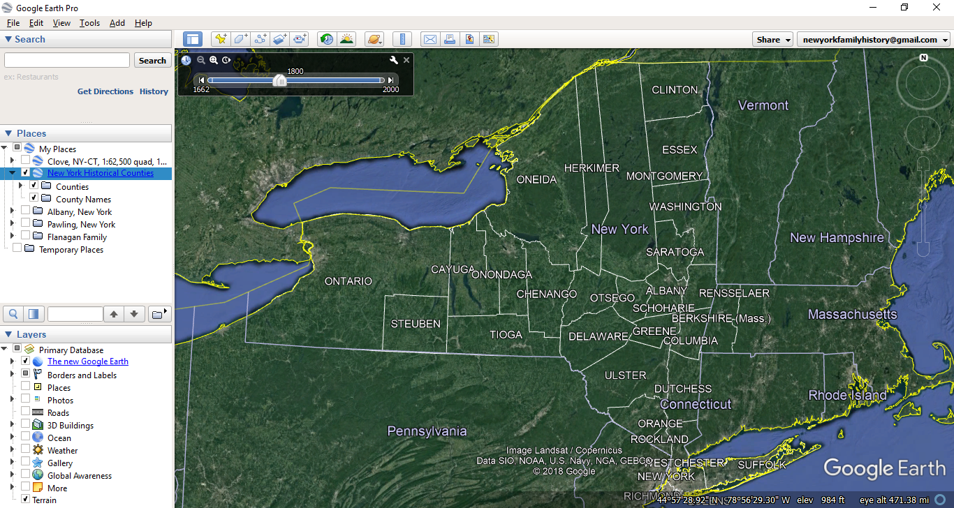
Google Earth Pro (Desktop)
Google Earth Pro is a popular tool that can be very useful to a family history researcher interested in exploring maps. It is a powerful desktop program that can run on most computers and is now completely free to download.
Google Earth Pro comes with modern geographic data that can be useful for exploring the present world. While Google Earth itself does not come with many historical maps, it is a tool that can be used to view and display historical maps you find elsewhere on the web. Many maps that can be downloaded from the below websites can be loaded into Google Earth with just a few clicks. Genealogists can also create and store their own information in Google Earth.
Whether you use it to organize your family history in a brand new way, to view and save historical maps (or ideally both), it's a fantastic free tool that can revolutionize your research. We have a two-part of blog series on this subject, as well as a webinar - Mapping Your New York Ancestors - that covers this subject and more tips for location-based research.
Read our blogs here:
- Google Earth for Genealogy, Part 1: Putting Your Ancestors on the Map
- Google Earth for Genealogy, Part 2: Adding Historical Maps & Data
Newberry Atlas of Historical County Boundaries
A project of the Newberry Library in Chicago, this website is a fantastic resource for exploring the changing boundaries of counties in all 50 states.
You can use an interactive map online to see borders of any county in the United States throughout history. This is incredibly useful to determine what jurisdiction you should be researching. County borders changed far more than many people realize - especially in New York!
Maps of each state can also be downloaded as .kmz files and then loaded into Google Earth.
Click here to visit the Newberry Atlas of Historical County Boundaries
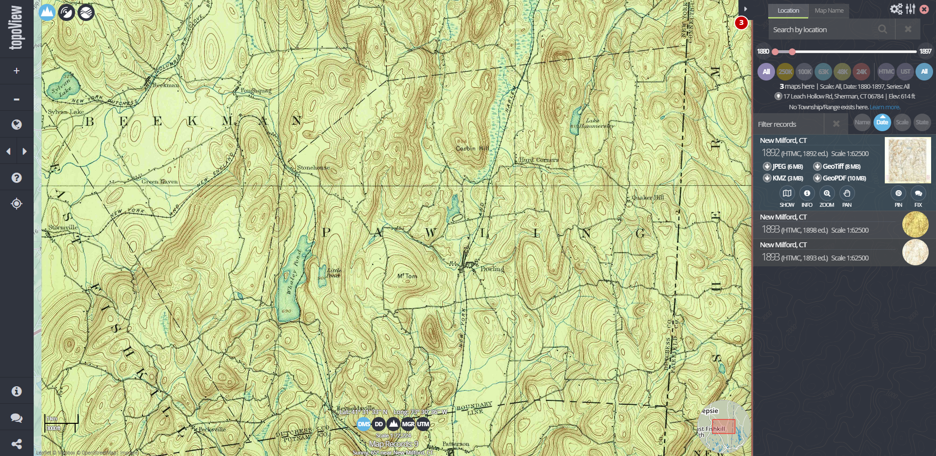
USGS Historical Topographic Maps
The United States Geological Survey has been mapping the nation's topography for nearly 150 years. Topographic maps show land contours, elevation changes, and other features related to the earth's surface - they are incredibly useful for family history researchers, especially when investigating rural areas.
Researchers can use an online tool called topoView to view these topographic maps in an online map viewer - search by location name or click, drag, and zoom the viewer to the location of interest. As soon as you zero in on a particular area, a number of map options will appear - each can be loaded right into the online viewer. You can also download each map to view as a digital image or load into an application like Google Earth.
Using topographic maps to learn more about your ancestor's landscape is covered in detail in our webinar Mapping Your New York Ancestors.
Click here to visit USGS topoView
NYPL Digital Collection
The New York Public Library maintains one of the world's premier map collections and has digitized thousands of their rare and historical holdings. Researchers can view digitized maps from the NYPL online at the NYPL Digital Collections.

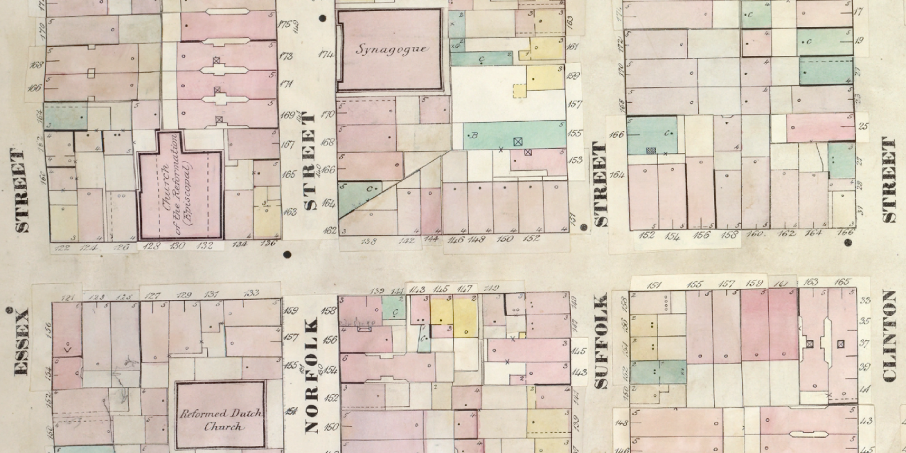
Fire Insurance Maps
This listing doesn't refer to one website by itself, but rather an important type of map that can be found in a few places on the web - fire insurance maps.
Many fire insurance maps were created in the nineteenth and twentieth centuries - these maps are among the most detailed maps you will be able to find, with highly accurate portrayals of buildings, property, and infrastructure. Many exist in physical form at various repositories throughout New York State, and most can be found online - but there is not currently a single database that holds all digitized fire insurance maps. One of the most prolific publishers of these maps was the Sanborn Map Company, so you may often hear these type of maps referred to as "Sanborn Maps," though in many cases you will find fire insurance maps created by other firms.
We recently published a detailed online guide to fire insurance maps and how they may be used. Read this article for important tips and links.
New York Heritage Digital Collections
New York Heritage is an online research portal that has a number of valuable collections for those researching the past. As a collaborative project of several libraries and archives from around New York State, a wide variety of subjects and localities are covered.
They have some excellent digital maps from all areas of the state, including the Holland Land Company Maps, which are particularly valuable for land record research in Western New York.
Click here to see maps available on New York Heritage
Geographic Names Information System (GNIS)
This website doesn't contain any visual maps, but it's an essential tool to use when researching historical locations or viewing historical maps. If you ever encounter a place name that doesn't seem to be used by contemporary maps or documents, this website should be your first stop to solve the mystery.
This database, developed by departments of the U.S. Government, is the official database for geographic names used by the Federal Government in the U.S. It includes contemporary and historical names and is an excellent resource for determining the exact location of a place with an unfamiliar or no-longer-used name. GNIS includes names of geographic features and uses a very expansive definition of what a feature is. Natural features like rivers, mountains, and forests are covered, but man-made features are included as well - schools, hospitals, bridges, and more will also be found.
Visit the USGS Geographic Names Information System
David Rumsey Historical Map Collection
The David Rumsey Historical Map Collection Database and Blog provides online access to over 90,000 online maps and images, with a focus on rare maps of North and South America. The site is free and open to the public - users can view high-resolution images of maps and use a number of tools to manipulate and analyze the maps.
Many of the maps have been georeferenced and can be downloaded and loaded into applications like Google Earth. Similar to the NYPL Map Warper, this website also has a tool with which users can georeference maps that have not yet been georeferenced. The website is best searched by location name or other keyword - search results can be narrowed down by state, and further by county and/or municipality.
Click here to visit the David Rumsey Map Collection
NYPL Map Warper
Update: the NYPL no longer supports the Map Warper tool, and is now only available as a non-interactive archived page.
The New York Public Library maintains one of the world's premier map collections and has digitized thousands of their rare and historical holdings. Researchers can view digitized maps from the NYPL online at the NYPL Map Warper.
Many of the digital maps on this website have been rectified - this means they have been adjusted and manipulated to align over a modern digital map. Rectified maps can be downloaded as .kmz files and loaded into Google Earth. Maps that have not yet been rectified can be viewed online or downloaded as a digital image file. Adventurous researchers can actually contribute to the rectification process, which is a little challenging but very fun - give it a try!
Click here to visit the NYPL Map Warper
Notable Map Collections in Physical Repositories
Columbia University: Lehman Library Map Collection
When the Lehman Library Map Collection was established in 1912, its focus was on geology and mineralogy. It has since expanded to include maps of all types and time periods and today houses approximately 115,000 sheets.
Its special collections include United States and Canadian Depository Maps; Geological Sciences Collection Series; General State, National, and International Map Series; U.S. Board of Engineers for Rivers and Harbors Port Series; and Nautical and Aeronautical Series. The University’s Rare Books and Manuscripts Library holds additional historical maps. Information on their holdings and important information for planning a visit is available on their website.
Website: Columbia University: Lehman Library Map Collection
Cornell University Library: Maps and Geospatial Information Collection
Located at the Olin Library at Cornell University, the Maps and Geospatial Information Collection holds over 240,000 maps, 3,200 books and atlases, and 500 compact discs and serves as a depository library for federal government maps and digital spatial data. It has a special focus on international topographic maps, historic and modern city plans, nautical charts, geological maps, reproductions of rare or historic maps, aerial photographs, and globes. Access to its digital collection is restricted to members of the Cornell University community.
Website: Cornell University Library: Maps and Geospatial Information Collection
Harvard Map Collection
Harvard University maintains a collection of over 500,000 maps, ranging from the 16th century to the present. Some of its holdings are digitized and may be accessed online. Highlights of the digital collections include maps of Boston, Cambridge, and other New England locations; maps of London and China; pictorial maps by Ernest Dudley Chase; fire insurance and real property atlases; and Revolutionary War maps. Additional material can be found by visiting the Collection in person at the Houghton Library.
Website: Harvard Map Collection
Library of Congress: Geography and Map Division
The Geography and Map Division of the Library of Congress proclaims itself “the largest and most comprehensive cartographic collection in the world,” housing over 5.2 million maps. Although its holdings range from local to global, encompassing the entire world and most of history, the Division’s collection of American material is particularly strong, including maps from the Colonial and Revolutionary Eras and American military maps.
The Division’s holdings may be accessed through its website or at the Geography and Map Reading Room at the Library of Congress in Washington, D.C.
Website: Library of Congress: Geography and Map Division
The National Archives: Maps and Geographic Materials
The National Archives’s Archival Research Catalog (ARC) provides a searchable index of approximately half of the material held by the Archives. Instructions for using the ARC to find maps and geographic materials are provided at the link below. You can also visit the National Archives in person. The address for their New York City facility is given below; you may also view a list of addresses of their other locations.
Website: The National Archives: Maps and Geographic Materials
New York Public Library: Lionel Pincus and Princess Firyal Map Division
The Lionel Pincus and Princess Firyal Map Division of the New York Public Library contains a collection of over 433,000 maps, some of which have been digitized. Researchers in the Map Division are currently engaged in a project combining maps and census data in order to illuminate both the conditions of specific time periods and change over time.
A large portion of the Division’s holdings can be accessed online through the Library’s catalog and Digital Gallery. More complete access is available through the Map Division reading room.
Website: New York Public Library: Lionel Pincus and Princess Firyal Map Division
New York State Archives (NYSA)
The NYSA’s holdings contain more than 80,000 maps, including maps of locations in New York State and neighboring states, military maps, insurance maps, land patents and surveys, and New York county atlases. The maps section of NYSA’s website provides a thorough history of map-making in New York and a bibliography of selected maps. NYSA's digital archive is also rich with several thousand maps. Each fall, the NYG&B hosts a Research in Albany Tour if you're interested in viewing the maps (and many other resources) available at the State Archives.
Website: New York State Archives
Stony Brook University Map Collection
The Map Collection at The State University of New York at Stony Brook includes 1,700 maps and atlases of Long Island and New York State, dating from 1640 to the present, in addition to aerial photographs, gazetteers, and books. A portion of its holdings are digitized and available online.
Website: Stony Brook University Map Collection
University at Buffalo Map Collection
The State University of New York at Buffalo maintains the largest collection of maps in Western New York, with holdings of over 320,000 maps, 4,000 aerial photos, and 500 atlases. Although the Collection includes maps of all parts of the world, it has a special focus on Buffalo and Erie County, New York State, the United States, and Canada. Its materials may be accessed online or at the Lockwood Library.
Website: University at Buffalo Map Collection
Yale University Map Collection
The Sterling Memorial Library at Yale University houses the largest map collection in Connecticut, including 200,000 map sheets, 3,000 atlases, and 900 reference books. It has a special collection of 11,000 rare map prints and manuscripts, most of which date from before 1850. The Library also offers a Geographical Information System, accessible through its website, and continues an initiative to digitize and catalog its holdings.
Website: Yale University Map Collection
This information was last updated on April 25, 2019. Additions, corrections, and comments may be sent to webmaster@nygbs.org.