
With this useful website, you can access a database of photographs for many locations in New York City throughout the ages. OldNYC helps users search New York Public Library’s photographic collection dating back to the 1870s in an easy-to-use map format.
Now, you just might be able to see for yourself where your ancestors lived exactly as they once did. From shopfronts to the fashion of passersby, the images from OldNYC can bring the world of your forebears back to life.
About OldNYC
The photographs draw from New York Public Library’s Photographic Views of New York City, 1870s-1970s collection, which comes from the Irma and Paul Milstein Division of United States History, Local History and Genealogy.
The OldNYC website was developed by Dan Venderkam as an alternative, location-centric way of browsing the many photos in this collection. Images are plotted by latitude and longitude via geocoding and cover all boroughs. Photo locations are transcribed with very detailed descriptions that typically indicate intersections, for example, “15th Street at 6th Avenue, Northeast corner.”
Finding an image
Your first step to finding a relevant image is retrieving an address for your ancestor. One possible place to do so, depending on the year, is a census record. If an address is available, you will generally find that information in the leftmost columns of the document. Many other types of records will also contain your ancestors' addresses.
When you have an address, input it into Google Maps, or any similar platform, to find the cross street(s) that are nearest the address. Also note the orientation of the building’s location on its block (north side of the street, southwest corner of the intersection, etc.).
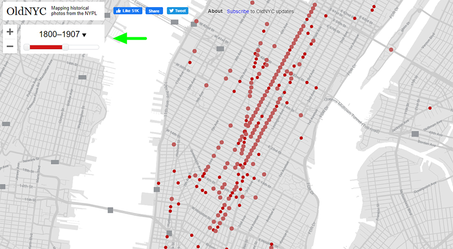
Then, head to OldNYC.org. Orient yourself with the new map, and zoom in to the precise location you are looking for. At this point, you can also filter for specific date ranges with the slider on the upper lefthand corner, if necessary:
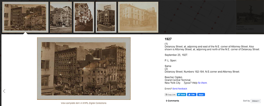
Once you have found your building, click on the nearest intersection. Select the red dot on any corner, and you will see all images of that location throughout the years.
If you are looking for a mid-block address, be sure to browse all surrounding intersections.
It is also essential to use the transcribed photo descriptions to orient yourself so you know exactly what you are looking at as you browse. Finally, please note while saving photographs that the library holds the copyright to all images.
Why you should explore OldNYC
OldNYC includes several other exciting features. On the right-hand side, you can browse their most popular images and even use the comment feature to talk about your area with other users. This website will allow you to see NYC like never before.
With one simple search, you can observe how the street corners you walk every day have changed with the eras. And for the family researcher, you can supplement your genealogical data with a rich and tangible glimpse of the place your ancestor lived, precisely as they saw and knew it.
Other ways to recreate the world of your ancestors
OldNYC is just one resource you can use to find visual sources that will help bring the world of your ancestors to life. If you have family that lived in New York City in 1940, there is almost certainly a photo of their building available online—read our article Find a photo of any NYC building from 1940 to learn about another New York City map and photo tool you can use.
Fire insurance maps (commonly called "Sanborn maps") are another great option. These detailed maps show every detail of neighborhoods from cities all over New York State. Learn how to use them and where to find them in our article Fire Insurance Maps: Sanborns and Others.
For rural locations in New York State, historical topographic maps are illuminating and very easy to find online. Learn all about that (and other historical maps) in Google Earth for Genealogy Part 2: Adding Historical Maps & Data.